下载中心
优秀审稿专家
- 2020年度优秀审稿专家
- 2019年度优秀审稿专家
- 2018年度优秀审稿专家
- 2017年度优秀审稿专家
- 2016年度优秀审稿专家
- 2015年度优秀审稿专家
- 2013年度优秀审稿专家
- 2012年度优秀审稿专家
优秀论文
相关链接
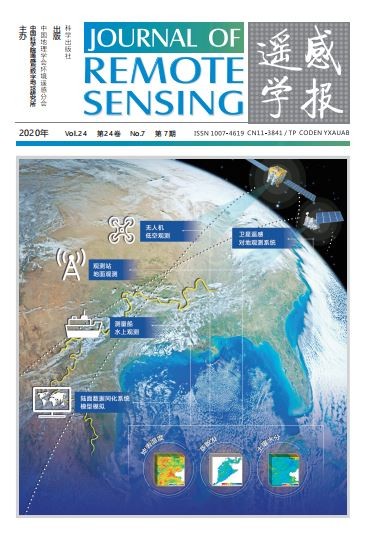
首页 > 2020年第7期封面报道
2020年第7期封面报道
水资源立体协同监测
封面图片为清华大学龙笛教授团队提供的“地面监测—遥感监测—陆面数据同化系统”三位一体的水资源立体协同监测体系示意图。其中,地面监测网络包括地面观测站及测量船水上观测等;遥感监测包括卫星遥感及无人机遥感监测等;陆面数据同化系统包括GLDAS 和CLDAS 等。利用“天—空—陆—水”多监测平台对水资源要素开展协同、优势互补的监测,对提升我国水资源的监控能力,特别是提升地表温度、蒸散发、土壤水分等要素在时空分辨 率、时空连续性和精度等方面具有重要意义。同时,对我国水资源管理部门在水资源精细化、动态化管理方面具有重要参考价值。相关研究进展,详见本期第787—803 页“基于多源信息的水资源立体监测研究综述”。
Water resources stereoscopic monitoring
The cover image shows a stereoscopic monitoring system for water resources using ground observations, remote sensing monitoring, and land surface data assimilation systems, provided by Professor Di Long from Tsinghua University. The ground observation systems include ground observations and ship-based surveys. Remote sensing monitoring systems include satellite- and Unmanned Aerial Vehicle (UAV)- based remote sensing monitoring. Land surface data assimilation systems include global and regional land data assimilation systems (e.g., GLDAS and CLDAS). Using different monitoring platforms to carry out coordinated and consistent monitoring of hydrological and water use variables is valuable in improving the monitoring capability of water resources in China. The monitoring of land surface temperature, evapotranspiration, soil moisture, and other variables has been reflected by improved spatiotemporal resolution, spatiotemporal continuity, and accuracy. Meanwhile, this study provides important insights into the precise and dynamic water resource management for different water resource authorities. For relevant research, please refer to“ A review on water resources monitoring systems based on multisource data” on pages 787—803 of this issue.