下载中心
优秀审稿专家
- 2020年度优秀审稿专家
- 2019年度优秀审稿专家
- 2018年度优秀审稿专家
- 2017年度优秀审稿专家
- 2016年度优秀审稿专家
- 2015年度优秀审稿专家
- 2013年度优秀审稿专家
- 2012年度优秀审稿专家
优秀论文
相关链接
首页 > 2020年第12期封面报道
2020年第12期封面报道
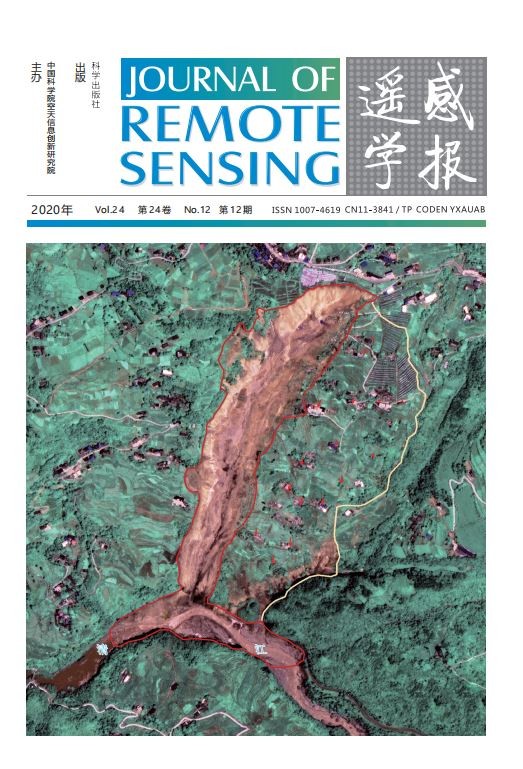
湖北恩施市沙子坝滑坡高分二号遥感监测
封面图片为2020年7月湖北恩施市屯堡乡马者村沙子坝滑坡及高风险区遥感监测图。利用2019年9月30日滑坡前和2020年7月27日滑坡后高分二号卫星(GF-2)正射遥感影像对比分析,图中红色范围为已发生大面积滑坡的区域,紫色范围为滑坡高风险区域(存在蠕动变形),红色箭头代表风险区内典型地物发生显著位移方向。通过对滑坡前后不同时相高分影像特征点匹配和变化检测,不仅可以精确提取明显的滑坡区和堰塞体信息,还可以对高风险区域滑坡蠕动位移方向和距离进行有效评估,对滑坡灾害应急监测及风险防控具有重要意义。
Shaziba landslide monitoring in Enshi City, Hubei Province, based on GF-2 remote sensing
The cover image is a remote sensing monitoring map of the landslide and high-risk areas of the Shaziba in the village of Maze, Tunbao Township, Enshi City, Hubei Province in July 2020. Using of the pre-landslide (September 30, 2019) and post-landslide (July 27,2020) orthorectified remote sensing images from the GF-2 satellite, the areas where large landslides have occurred are shown in red, the areas at high risk of landslides (with creeping deformation) are shown in purple, and the red arrows represent the direction of significant displacement of typical features within the risk areas. By matching and detecting changes in high resolution image features in different phases, before and after a landslide, it is possible not only to accurately extract information on obvious landslide areas and weir bodies, but also to effectively assess the direction and distance of creeping landslide displacements in high-risk areas, which is of great significance for emergency monitoring and risk prevention and control of landslide disasters.