下载中心
优秀审稿专家
- 2020年度优秀审稿专家
- 2019年度优秀审稿专家
- 2018年度优秀审稿专家
- 2017年度优秀审稿专家
- 2016年度优秀审稿专家
- 2015年度优秀审稿专家
- 2013年度优秀审稿专家
- 2012年度优秀审稿专家
优秀论文
相关链接
首页 > 2020年第11期封面报道
2020年第11期封面报道
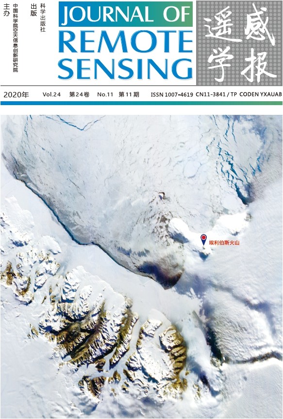
京师一号小卫星南极维多利亚地的真彩色合成影像
封面图片为京师一号小卫星搭载的宽幅成像仪 2019 年 9 月 29 日获取的南极维多利亚地的真彩色合成影像,展现了南极冰雪、裸岩等典型地物纹理信息,成像具有较好一致性,其中位于罗斯岛的层状火山——埃里伯斯火山为南极最大的活火山,火山口形成的水蒸气在影像中清晰可辨。京师一号(又 名“冰路卫星”)由北京师范大学联合中国长城工业集团有限公司、深圳东方红卫星科技有限公司共同研制,于 2019 年 9 月 12 日发射入轨,是我国首 颗极地观测遥感卫星,也是“三极遥感星座观测系统”的首颗试验卫星。卫星采用太阳同步轨道,轨道高度为 739 km,主载荷为一台分辨率 74 m、幅 宽 744.29 km 的宽幅成像仪,具有大幅宽、高重访、可在轨变更曝光时间的特点,能够实现 5 d 内两极地区的全覆盖,主要用于极地气候与环境监测, 应急模式下能够提升对极地突发事件的连续监测能力,弥补了我国长期自主极地观测数据的短缺,对于促进我国极地与全球变化研究具有重要意义。卫 星自发射入轨以来,已获取影像 2501 幅,生产高质量少云的南北极 1 级遥感数据产品超过 280 景,产品分辨率为 80 m。以上数据均可在卫星数据引 接系统(http://earth.bnu.edu.cn)免费下载。
True color composite image of Victoria Land in Antarctica by the Jingshi-1 (BNU-1) microsat
The cover image is a true color composite image of Victoria Land, Antarctica, acquired on September 29, 2019 by the wide-swath camera
carried by the Jingshi-1 (BNU-1) cubesat, showing the texture information of typical features such as ice, snow and bare rock in Antarctica.
The layered volcano Erebus on Ross Island is the largest active volcano in Antarctica, and the water vapor formed in the crater is clearly
distinguishable (the red mark). BNU-1 is China's first polar-observing microsat, and is also the first experimental satellite of the "Tri-pole
Remote Sensing Constellation Observation System", jointly developed by Beijing Normal University, China Great Wall Industry Corporation
and Shenzhen Aerospace Dongfanghong Satellite.Ltd, launched into orbit on September 12, 2019. The satellite adopts a sun-synchronous
orbit with an orbital height of 739 km. The main payload is a wide swath camera with a resolution of 74 m and a width of 744.29 km with
wide observation area, short repetition visit period, and the ability to change the exposure time in orbit. It can achieve full coverage of
the Antarctic and Arctic within five days, mainly used for polar climate and environmental monitoring and can improve the continuous
monitoring ability of polar emergencies. BNU-1 has acquired 2501 images since it was launched into orbit. At present, more than 280
scenes of high-quality, low-cloud L1B products have been produced (with a resolution of 80 m). The L1B data can be downloaded for free
in the satellite data connection system (http://earth.bnu.edu.cn).