下载中心
优秀审稿专家
- 2020年度优秀审稿专家
- 2019年度优秀审稿专家
- 2018年度优秀审稿专家
- 2017年度优秀审稿专家
- 2016年度优秀审稿专家
- 2015年度优秀审稿专家
- 2013年度优秀审稿专家
- 2012年度优秀审稿专家
优秀论文
相关链接
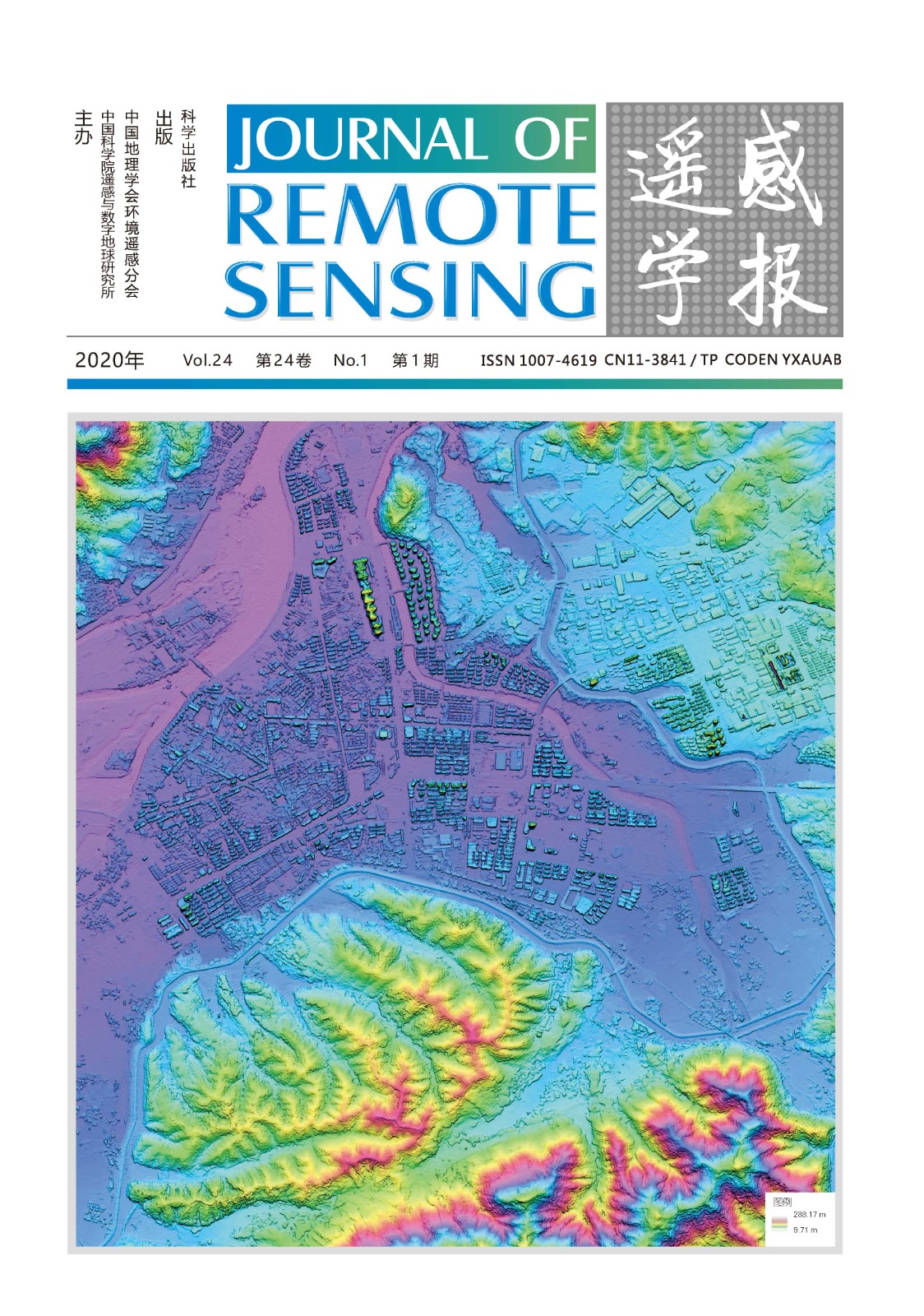
首页 > 2020年第1期封面报道
2020年第1期封面报道
高分七号卫星影像生成的数字表面模型晕渲图
封面图片为 2019 年 11 月 23 日获取的安徽省泾县高分七号卫星影像生成的数字表面模型(DSM)晕渲图,空间分辨率为0.65 m。高分七号卫星是我国首颗亚米级高分辨率光学传输型立体测绘卫星,配置有双线阵相机和激光测高仪两种载荷,可以同时获取高空间分辨率立体测绘遥感数据和高精度激光测高数据。其中双线阵的两台相机从前视、后视两个角度观测地物,获取地物全色影像,实现对全球表面立体测量,同时后视相机可以获取四谱段多光谱数据制作彩色影像,观测信息更丰富。激光测高仪则在沿飞行方向左右各配置一个激光测距波束及激光足印相机,距离测量精度优于0.3 m,地面像元分辨率优于3.2 m,可以大幅提升光学立体影像在无控制点条件下的高程精度。高分七号卫星将在1:1万立体测图、自然资源监管、住房和城乡建设、国家统计调查等方面发挥重要作用,为城市群发展规划、生态环境保护、农业农村建设、交通信息化建设提供有力保障,为生态文明建设、国家治理体系现代化提供重要支撑。
Shading Map of Digital Surface Model Based on The Image of GF-7 Satellite
The cover image is the shading map of digital surface model (DSM) based on the GF-7 satellite image of Jingxian County, Anhui Province, obtained on November 23, 2019, with a spatial resolution of 0.65 m. GF-7 satellite is the first sub meter high-resolution optical transmission three-dimensional surveying and mapping satellite in China. It is equipped with two kinds of loads: a dual line array camera and a laser altimeter. It can obtain high-resolution three-dimensional surveying and mapping remote sensing data and high-precision laser altimetry data at the same time. The two cameras of the dual line array observe the ground objects from the front view and the back view to obtain the panchromatic image of the ground objects, and realize the stereoscopic measurement of the global surface. At the same time, the back view camera can obtain the multi-spectral data of four spectral segments to make the color image, and the observation information is more abundant. The laser altimeter is equipped with a laser ranging beam and a laser footprint camera along the flight direction. The distance measurement accuracy is better than 0.3 m, and the ground pixel resolution is better than 3.2 m, which can greatly improve the elevation accuracy of optical stereo image without control points. GF-7 satellite will play an important role in 1:10000 stereoscopic mapping, natural resource supervision, housing and imaging construction, national statistical survey, etc., providing strong guarantee for urban agglomeration development planning, ecological environment protection, agricultural and rural construction, transportation information construction, and providing important support for national ecological civilization construction and national governance system modernization.